

The Best Spots for Photos in Yosemite National Park
- Molly
- Jul 14, 2020
- 6 min read
Updated: Jan 20, 2021
Yosemite National Park is a photographer's paradise! Whether you're a professional or you just want to add some epic memories to your scrapbook, be sure to visit these photo spots that offer the best views in Yosemite National Park.

One of the main reasons I wanted to live in the Bay Area is due to the close proximity to Yosemite National Park (and so many other National Parks)! I've been to Yosemite once when I was younger, but it was before I really appreciated the Parks like I do now. Even so, this place struck a chord with me and I've been longing to get back ever since.
There's a reason that Yosemite is so popular - it's breathtakingly beautiful at every turn, with some of the greatest Hiking trails and Waterfalls in North America. It's really hard to capture the true magnitude of the mountains and landscape here through photographs, but that's part of what makes this place so special.
If you're planning a trip (or need some inspiration to start), check out the below for the absolute best spots for photos in Yosemite National Park!

The Best Spots for Photos in Yosemite:
Glacier Point
Location: At the end of Glacier Point Road
Parking: Ample spaces in the Glacier Point Parking Lot
Accessibility: Late May - Early November
Driving Distance from Yosemite Valley: 1 hr
Best Time of Day for Photos: Sunset
With sweeping views of the iconic Half Dome, Glacier Point is a must-see while visiting Yosemite. During sunset, the sun illuminates Half Dome while offering a beautiful, multi colored sky.
I would arrive no later than one hour before the sun sets for best views and to ensure you get a parking spot.
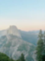


You can also find sweeping views from the Geology Hut, pictured below

* Please note - Glacier Point Road will be closed in 2022 for repairs, so your only option to see Glacier Point will be by hiking the strenuous Four Mile Trail, which begins in the Valley and contrary to the name, it's 9.2 miles round trip
For more information on Glacier Point, check out what the NPS has to say here.
Taft Point (Hiking Required)
Hiking Distance: 2.2 miles roundtrip, easy
Location: Glacier Point Road, Taft Point Trailhead
Parking: Some spaces at the trailhead, ample parking available on the shoulder of Glacier Point Road
Accessibility: Late May - Early November
Driving Distance from Yosemite Valley: 1 hr
Best Time of Day for Photos: Late afternoon or sunset
The quick trail along Taft Point and the Fissures leads to some truly epic views of El Capitan and the Valley.
Since the sun was setting above the view of the Valley, it was a little hard to capture the detail in photos, but I would still recommend going at sunset. The bright sun and hazy background added to the ambiance.

Taft Point is one of those places that just makes your jaw drop not only from the stunning views, but also from the steep drop off. Your fear of heights will surely be tested! Don't worry - at no point on this trail are you forced to be close to the edge.


* Please note - Glacier Point Road will be closed in 2021 for repairs, so this trail will not be accessible
Tunnel View
Location: Wawona Road (Hwy 41)
Parking: Around 50 spots available, as well as spaces for RV's (Parking can be an issue at sunset)
Accessibility: Year-round
Driving Distance from Yosemite Valley: 10 minutes
Best Time of Day for Photos: Afternoon or sunset
Tunnel View is your first glimpse at the Valley once you exit the Wawona Tunnel. This is one of the most photographed locations in Yosemite because it allows for views of El Capitan, Bridalveil Fall, and Half Dome in one shot.
During peak tourist season and around sunset, I've heard parking can be an issue.


Valley View
Location: Northside Drive, right before the park exit
Parking: Limited spaces - around 10
Accessibility: Year-round
Driving Distance from Yosemite Valley: 10 minutes
Best Time of Day for Photos: Any! I enjoyed this in the early afternoon, when the sun was in full effect! It can probably be shadowy after sunrise/just before sunset - try to get a handle on what you're aiming for!
I love Valley View because you're able to capture the Merced River in your photographs. This would be a lovely place for a picnic!


Cook's Meadow Boardwalks
You have the option to hike the easy, 2.2 mile Cook's Meadow/Sentinel Dome Loop for many similar views, or you can snag this photo as easily as parking and walking a couple hundred feet.
Location: Southside Drive, Across from Yosemite Valley Chapel
Parking: Street parking along Southside Drive
Accessibility: Year-round
Driving Distance from Yosemite Valley: Located in Yosemite Valley
Best Time of Day for Photos: Any
This was without a doubt my favorite place to photograph Yosemite Falls. Yosemite Falls is the tallest waterfall in North America, but keep in mind that peak season for the falls is during Spring, and by August it is usually completely dry.

This photo was taken in early July, so as you can see, the falls are already looking a bit lackluster.
The Summit of Upper Yosemite Falls (Hiking Required)
Hiking Distance: 7.2 miles roundtrip, very strenuous
Location: Yosemite Falls Parking Area (Camp 4), Right across from the Upper Yosemite Falls Trailhead
Parking: Ample parking, but fills up later in the day
Accessibility: Year-round
Driving Distance from Yosemite Valley: 1 minute
Best Time of Day for Photos: Start the hike as early as possible - it gets extremely hot in the Summer!
The reward was well worth the effort on this trail, but I'll be honest, this one was tough. Zach and I saw 7 miles and thought, "piece of cake!" but this trail was relentless at times. It is steep and rocky the entire way up, and the way down takes just as much of a toll on your body.
Regardless of difficulty, any avid hiker should not skip this trail. The views are endless and unforgettable!


More views along Upper Yosemite Falls


Vernal & Nevada Falls via the Mist Trail (Hiking Required)
Many people choose to only hike until Vernal Fall, but it's worth it to go the short distance further to reach Nevada Fall.
Hiking Distance: 7.3 miles round trip, strenuous
If hiking the Mist Trail there and back, it is 2.4 miles round trip to Vernal Fall, and 5.4 miles round trip to Nevada Fall.
I recommend hiking up the Mist Trail to Nevada Fall, then hiking down the John Muir Trail on your way back. (During COVID, this is your only option). The JMT is a bit longer, but less strenuous and offers great views. Total round trip mileage will be 7.3 miles with this suggested route.
Location: Yosemite Falls Parking Area (Camp 4), Right across from the Upper Yosemite Falls Trailhead
Parking: Closest parking is at Yosemite Valley Trailhead Parking which fills up very early, and is a half a mile from the trailhead. Shuttles are not running for 2020, but once they're running again, you can park at the Visitor Center and take a shuttle to the trailhead.
Accessibility: Year-round, with some trail portions closed during Winter
Driving Distance from Yosemite Valley: 5 minutes
Best Time of Day for Photos: Start the hike early - it gets extremely hot and crowded!
This is another tough trail for many people - we saw a lot of people take numerous breaks, as the incline seems never-ending. Once you reach the steps along Vernal Fall, you'll see why this is one of the best photo spots in Yosemite!
It only gets better and more grand once you reach the top of Nevada Fall. In my opinion, these waterfalls are more impressive than Yosemite Falls during the Summer.


El Capitan from the Merced River
Location: Southside Drive, near the El Capitan Bridge
Parking: Park near the El Capitan Bridge and walk down to the River (OR type in Cathedral Beach for similar views of El Cap)
Accessibility: Year-round
Driving Distance from Yosemite Valley: 5-10 minutes
Best Time of Day for Photos: Any
Zach and I have seen the documentary "Free Solo" countless times, but nothing compares to seeing El Capitan in person. ICYMI - Alex Honnold became the first person to free solo (rock climb without ropes) El Capitan in 2017.
This photo spot was perfect on a Summer day because we were able to go in the water and lay out for a bit. The Merced River was very cold in early July, but still refreshing.


Bonus: You can also view El Cap as you are exiting the Park in the El Cap Meadow (see below)! There is parking along the side of the road on Northside Drive - you can't miss it.


Other Notable Photo Spots Outside of the Valley:
Tuolumne Meadows
Tenaya Lake
Olmstead Point
Enjoy your trip to Yosemite! Let me know if you make it to any of these epic photo spots.
